Race
Details
SATURDAY
RACE IS CANCELLED DUE TO FLOODING.
Roads
are already impassable, with continuing thiunderstorms
and steady rain expected.
Update
April 3 at 0820. New to the Pig. There will be no paper info packet printed
this year. Please look online or print
whatever schedule, locator map, and course info details you need in advance.
Update,
April 1 at 2355: No metal studs or
spikes are permitted on the Sunday Urban Middle race.
Update,
April 1 at 2345: Heavy rain is possible
Friday night. This could affect your
route to Story on Saturday morning.
IN 135 is subject to flooding just south of Gnaw Bone. Alternate Route: From Nashville and Gnaw Bone, continue east
on Route 46 and turn right onto Mt. Liberty Rd. proceed onto Valley Branch Rd.
to a left turn onto SR 135, and follow 135 to Story.
Indiana
Crossroads Orienteering and Orienteering Cincinnati are excited to welcome you
to the 2025 Flying Pig Meet. From the Fri. middle race at the Ransburg
Scout Reservation on beautiful Lake Monroe, to the physical long race in the
wilds of Hoosier National Forest near the historic town of Story, and the urban
middle distance race in downtown Indianapolis you will have the chance to
experience town and country Indiana. All three races are sanctioned as
National Ranking Events by OUSA.
Event
Directors:
Brenda Blacklock (ICO) and Mike Minium (OCIN) Course Consultant: Peter
Goodwin
Maps
Friday Middle maps will
be 1:10,000, 5 meter contour for orange, green, red and blue courses.
1:7500 for white, yellow, and brown.
Saturday Long maps will be 1:10,000, 5 meter contours for green, red and
blue courses. 1:7500 for white, yellow,
orange, brown, green.
Sunday Urban Middle maps will be a
sprint scale of 1:3000 for most courses and 1:2500 for brown A. The brown A 2500 scale may require a map
flip (TBD). Contour interval is 2
meters.
See the description of each day below
for more specifics.
Courses
All standard USA courses and classes
will be offered.
Control Descriptions
Control descriptions are printed on
your map. Loose description sheets may
be picked up when you enter the call-up area, 2-3 minutes before your
start. Descriptions for white and
yellow courses are in English only.
Descriptions for orange course and above are in IOF symbols only.
Control Markers
Control markers will be IOF standard
orange and white flag. Control markers
will have a blue stripe, either diagonal or vertical.
Course Length (km) and
Climb (m) Table
Lengths
are straight line, climb is along “optimal” route.
|
Course |
Classes |
Friday
– Middle Ransburg |
Saturday
– Long Story
West |
Sunday
-
Middle Indianapolis |
|
, |
Course
Setter |
Dylan
Poe |
Mattias
Eriksson |
Rob
Minto |
|
1
White |
F-10,
F-12, F white, M-10, M-12, M white, Group white |
2.0
km, 65 m |
1.9
km, 50 m |
1.4
km, 10 m |
|
2
Yellow |
F-14,
F yellow, M-14, M yellow, Group yellow |
2.2
km, 75 m |
3.1
km, 95 m |
2.0
km, 15 m |
|
3
Orange |
F-16,
F orange, M-16, M orange, Group orange |
3.3
km, 90 m |
4.4
km, 165 m |
3.8
km, 30 m |
|
4
Brown A |
F65+,
F70+, F75+, F brown, M 75+, M brown, all 80+ classes |
2.3
km, 85 m |
3.1
km, 125 m |
2.6
km, 30 m |
|
5
Brown B |
F-18,
F55+, F60+, M65+, M70+ |
2.6
km, 135 m |
4.2
km, 145 m |
2.9
km, 35 m |
|
6
Green A |
F35+,
F40+, F45+, F50+, F green, M green |
3.1
km, 145 m |
5.5
km, 180 m |
3.8
km, 45 m |
|
7
Green B |
F-20,
M-18, M50+, M55+, M60+ |
3.4
km, 155 m |
6.3
km, 185 m |
3.8
km, 45 m |
|
8
Red |
F-21+,
M-20, M35+, M40+, M45+, M red |
3.8
km, 180 m |
8.1
km, 335 m |
4.3
km, 45 m |
|
9
Blue |
M-21+ |
4.5
km, 210 m |
10.4
km, 510 m |
4.5
km, 50 m |
Start Procedures
Clear and check your SI card when
you arrive in the start area.
You will be called up 3 or 4 minutes
before your scheduled start.
2 minutes before your start, you
will move forward and may pick up loose control descriptions. White and yellow may pick up their maps,
mark name/number on the map, and preview the map.
1 minute before your start, you will
move forward to the map line. You may
mark your name / number on the back of the map.
Do not look at your map (white/yellow may preview map). You may ask the starter to check that it is
the correct course.
When the beeper sounds, you punch
“start” and pick up your map.
There may (or may not) be a short streamered run to the start triangle shown on your map (to
be determined). You must run to the
triangle. There is a flag but no punch
at this point. At this point you may
begin navigating to your first control.
Drinking Water on
Courses
There will be limited water stops on
courses longer than 3 km. Water at
controls will be shown with a cup symbol on your descriptions. If water is not at a control, it will be
shown with a cup symbol on the map.
Time Limits
Time limit will be 2 hour for the Middle on Friday, 3 hours for the Long on
Saturday and 2 hours for the Urban Middle on Sunday.
Ticks
Tick season comes early to southern
Indiana and we’ve already seen ticks in
Indianapolis. (I’ve even found ticks in Indiana in Jan and Feb!). Treating shoes, socks, and other clothing
with permethrin is the best way to avoid them. Always do a tick check after
your run.
Warm-up Areas
On Friday, there will be a map with
a warm up area showing the walk to the starts.
Pick up this map at the check-in table.
On Saturday, there is no warm-up
area map. When you get off the bus, you
will be on a public gravel road with private land on both sides. Warm-up along the road, away from the couple
private residences along the road.
Expect a couple wet-foot fords on the walk to the start. There will be a couple portable toilets in a
gravel pull-off between the bus stop and the start. If you want to get off-road, just east of the
bus stop, you may hike south on the Browning Mountain (Indiana’s Stonehenge)
trail, but it is not mapped.
On Sunday, there is no warm-up area
map. You may warm-up in the parking
garage, between the parking garage and the natatorium (restrooms in the natatorium),
and along the road between the parking garage and the start.
Friday – Ransburg Scout
Reservation – Middle Distance
7599
Waldrip Creek Rd, Bloomington, IN 47401
Directions: From
Bloomington, take SR446 south across Lake Monroe Causeway, then turn right on
Waldrip Rd just south of the reservoir. From Columbus and Nashville, take
SR46 west to SR446, turn left and follow to Waldrip Rd. Parking is in a
large parking lot on the east side of the central camp area. Event
headquarters is in the Horton STEM shelter across the small road from the
climbing wall.
Parking is a large gravel
parking lot, 100 m to registration, 200 m to finish. The last 3 miles to the camp are on a gravel
road.
Finish The finish will be close to registration and
parking (under 200 m).
Restrooms
will be modern, indoor near registration and finish. No facilities at the start.
Walk
to the start is 400 meters for white, yellow, brown and 1700 meters for
orange, green, red and blue, including a long uphill
on a gravel road.
Clothing
Return Warm-up clothing may be left at the call-up
areas, and will be returned to the finish area.
Map Notes:
The Ransburg Scout Reservation was originally
mapped in the late 1990’s, partially by Vladimir Zherdev, and has been updated
several times since with the latest updates in early 2025 to the 2017 ISOM
standard.
- Map Scale:
1:10000 for Orange, Green, Red, and 1:7500 for White, Yellow, Brown.
Contour interval: 5m contour.
- The Ransburg map
has one non-standard symbol, a solid 1mm wide olive-green line that
represents the boundary between the camp and Hoosier National Forest. Orange, Green, Red, and Blue courses will cross this line, perhaps multiple
times. It is NOT an uncrossable
boundary. Trees along the boundary
are sporadically marked with red paint on one side, so you may or may not
be able to identify it on the ground, depending where and from which
direction you approach it.
- Rootstocks are not
mapped. A windstorm in June 2024 created several large rootstocks, but
they were not added to the map.
- Even though
rootstocks are not mapped, areas with several fallen trees are indicated
by green slash where running is more difficult.
- Depressions and
knolls are remains of old rootstocks.
- There are around
100 camping platforms, roughly 5x5 feet with an aluminum structure on top,
these are not mapped. There are also a number of
shelters for storage, these are also not mapped. Small buildings, usually
bathrooms, that have walls, are mapped as buildings.
- Vegetation
boundary generally indicates an area of pine forest. Distinct vegetation boundaries are
the newer dashed green line symbol, not the old dotted black.
- Cliffs and
boulders are generally less than 1m in height, but are distinct in the
terrain
Course Setter (Dylan Poe) Notes:
We will be using two start locations.
- There is a 400m
walk to the white/yellow/brown starts from end of parking lot
- There is a 1.7k
walk to the orange/green/red/blue start from end of parking lot
- Be sure to check
control codes, there are many controls in a small area.
White, yellow and brown maps are letter size (8.5 x 11) portrait
(vertical) at 1:7500
All other maps are
letter (8.5 x 11) portrait at 1:10,000
Saturday – Story West –
Long Distance
Story
Inn, 6404 IN-135, Nashville, IN 47448
Due to very limited parking at the start and
finish locations, there will be a bus shuttle from the tiny town of
Story. All participants are required to park in Story. The proprietors of
the Story Inn (https://storyinn.com/) have been very generous in providing
space for parking free-of-charge. Please show your appreciation by
stopping in for a snack and/or drink at the Story Still Tavern and Grill after
your race.
Directions: From Bloomington, take SR46 east to turn right
on SR135 at Nashville and follow SR135 south to Story (right turns in Gnaw Bone
and Stone Head). From Nashville, follow SR 46 east, then SR135 south to
Story. From Columbus, take SR46 west and turn left onto SR135 at Gnaw
Bone. Parking will be in a pasture (weather permitting) just east of the
Story intersection. Alternate Route: IN
135 is subject to flooding just south of Gnaw Bone. If heavy rains occur Friday night or into
Saturday, plan to use this route. From
Nashville and Gnaw Bone, continue east on Route 46 and turn right onto Mt.
Liberty Rd. proceed onto Valley Branch Rd. to a left turn onto SR 135
Event Check-in Check in (and
recreational registration) will be outdoors near parking at Story Resort.
Bus to Start There is a bus
ride from the parking to the start and back from the finish. You should be planning to be at the bus stop
one hour before your start. A bus will
leave approximately every 15-20 minutes.
Expect a 15-20 minute ride to the start (half
that to the finish). The bus can stop at
the finish, as needed in either direction.
NO cars may travel to the start or finish. This is a narrow one-lane gravel road, with
curves and a steep hill. Buses will be
timed to pass each other at or near the finish.
Walk to the Start There
will be a roughly 1 kilometer walk from the bus drop off. The walk to the start is on a relatively
flat country lane with multiple, possibly wet-foot, stream crossings. Expect these fords on
the walk to the start to possibly be ankle-deep. There are a couple houses along the way;
please be reasonably quiet and courteous to these folks who live way back on
this remote dead-end road and probably don’t see a lot
of foot or vehicle traffic.
Finish There will be a bus
ride from the finish back to parking and registration.
Parking Park as directed in
the overflow lot and field at Story Resort.
Restrooms Portable toilets
are near parking, the finish, and the start.
Clothing Return Warm-up
clothing may be left at the call-up areas, and will be returned to the finish
area.
Map Notes:
The
Story West map was mapped as a COVID project beginning in 2020 by Robert Minto
and has been updated in early 2025 to include vegetation and point features to
the 2017 ISOM standard.
- Mapped at 1:10,000
with 5 m contours
- Rootstocks are
mapped (brown triangles) as of Mar. 19,
2025.
- Old rootstocks
with minimal root wood exposed are mapped as dot knolls.
- A dashed green
vegetation boundary frequently indicates the edge of largely pine forest.
In
the cooler months of the year, Story and Story West are fun, generally open
running. Most deeper woods and steep hillsides of Hoosier National Forest
are white or light green. The transition from white to light green is
often very subtle; this map was created with an eye to the runnability in
September or early May when areas with saplings will impede your vision.
Southern
Indiana forests typically have more than a bit of greenbriar,
infrequent raspberry/briar patches and uncommon multiflora bushes (resistant
leg cover is a way better plan than shorts). Mapping of the sharp
vegetation with green bars focused on areas where it was less avoidable and
mostly knee-high or greater. Where it might significantly affect choices
on ridges and in valleys, it is mapped with vertical green lines. In some
of the more dense areas of vegetation, briars are
indicated in two ways. First, scattered bushes are shown as green
bars. Denser patches, occasionally head high, are shown by tight green
bars; they collect tariffs in blood. Areas of dense medium and dark green
vegetation has the potential be spiky too! Fight and double green bars
will definitely lower your fun quotient!
Contours
(5 m with some form lines) are smoothed partially redrawn, KP contours from
2017 state LIDAR. Shallow ditches and reentrant basins that have active
erosion tracks but are dry, except in heavy rain, are dotted ditches.
Gullies are occasionally used for steeper sections of ditches/reentrants.
Intermittent streams are rockier and will be wet in the spring.
Earth
banks along streams were rarely mapped, and only if they were large and too
steep to pass. The N edge of the map is bordered by Salt Creek.
Unless it is flooded, it has very high unmapped earth banks and a very
mucky bottom. Stay out of it! Many of the flowing streams also have
unmapped 1-2 m banks, particularly at bends.
Expect
that rock features, cairns, and erosion gullies are often much smaller than
standard. Small rock bands were mapped if they were distinct, even if
they are minor. Although most of the cliffs are small, the E edge of the
map has some that we don’t want you falling off!
The
forest has patches of transitional forests with pines planted for erosion
control reaching the end of their lifespan; also, the area has had several
major wind events in the past 5 years. Most rootstocks, mapped as brown
triangles, are >1 m high. Many recently fallen treetops appear as
medium to dark green patches. Dot knolls may be small hills or the mostly
earthy remains of rootstocks and may only be 0.5-m high on the leading edge.
Brown
County has had many homesteads prior to 1940 disappear into the woods. It
is good land for orienteering but a tough life for a farmer! There may
be faint ruins, beds of daffodils, and wells. Mapped deep wells and
cisterns (blue squares) are generally covered; show care around the many
smaller mapped wells, which have narrow openings. Black X is used for old
junk piles, large tires, cars, and substantial but solitary fence posts and
survey markers. Ruined fences are not navigable but can be trip hazards.
Course setter (Mattias
Eriksson) notes:
Story
West offers mostly open, runnable woods with typical southern Indiana hills and
ravines making this an excellent property for long distance orienteering. Greenbriars are frequent across much of the area, even in
some of the white forest, and leg protection (at least long pants) is strongly
recommended.
The
courses have been set with an emphasis on long legs and route choices across
the physically demanding hilly terrain. They will also challenge your technical
orienteering skills as parts of the map have plenty of details, and you should
expect control flag placements to be low (meaning that you'll
often have to be nearby and on the right side of the control feature to see the
flag).
Note
that parts of the area sustained significant storm damage just a few weeks ago,
and, while we have made serious efforts to update the map accordingly, it is
highly likely that there are still some new root stocks/fallen trees that have
not yet been mapped.
Water
will be available at least once on the longer courses (green, red, blue), but
bringing your own can be a good idea if you think you are likely to be out for
two hours or more, given the rugged and physically demanding terrain,
particularly if the weather is hot.
Special
notes for the White and Yellow courses: Early on your courses, you will
encounter and follow a somewhat unusual trail that is wide but not frequently
used and has some fallen trees across it. It may thus be harder to follow than
a typical trail. You will also have a taped/streamered
route from the second last to the final (go) control straight through the woods
(where there is no trail).
Red and Blue maps are letter (8.5 x
11) portrait at 1:10,000
All other Saturday maps are tabloid
(11x17) portrait at 1:7500
Sunday – White River
State Park and Indy Canal
IUI
Riverwalk Parking Garage, 245 University Blvd, Indianapolis, IN 46202
**No
metal spikes or studs permitted on Sunday**
The urban middle distance race in
downtown Indianapolis will be all about route choice in what has been described
by a Canadian WOC team member as world-class sprint terrain.
Directions: From
the south (Columbus and Nashville), take I65 north to I70 west and exit at S.
Missouri St. (exit 79A); continue north on Missouri St./West St. to turn left
onto Michigan St. then left onto University Blvd. to the visitors
entrance of the Riverwalk Parking garage. From Bloomington, take I69
north to W. Southport Rd. exit, turn right onto Southport Rd. and then left
onto Bluff Rd.; follow Bluff Rd./Missouri St./West St. to turn left onto
Michigan St. then left onto University Blvd. to the visitors
entrance of the Riverwalk Parking garage. The Riverwalk garage must be
approached using the Michigan St. to University Blvd. route. Visitor
parking fees are $5 for 0 - 2 hr; $7 for 2 - 4 hr; and $9 for 4 - 6 hr payable
at Pay Station near the garage entrance. Warm up area is west of the
parking garage and the start call-up area is east of the garage. Portions
of the City of Indianapolis west of Illinois St, south of 11th St,
east of the White River, and north of Maryland St. are embargoed until after
your race with the exception of the route to the
parking and warm up area described here.
Maps: Sprint scale
maps for a Middle Distance race. Map scale: 1:3000 with 2 m contour
interval for most classes; 1:2,500 for some Brown classes (Brown A maps)
Event Check-in Check in
(and recreational registration) will be outdoors neat the ….
Finish The finish will be
relatively close to parking and registration.
Parking IUI Riverwalk
Parking Garage, Fees are $5 for 0 - 2 hr; $7
for 2 - 4 hr; and $9 for 4 - 6 hr
payable at Pay Station near the garage entrance. The garage has an 8’2” clearance on the lower
level and 7’ on upper levels. There are
nearby surface lots for large vehicles.
Walk to the Start Start will be a short and relatively flat walk, just to the
southeast of the garage
Restrooms Modern indoor facilities
at the Natatorium just to the west of the Riverwalk Garage
Clothing Return None; start
will not be far from parking and the finish.
Course notes and
special symbols
The map is ISSOM (sprint
standard),
Map Notes:
The
Indianapolis canal and IU Indianapolis campus area was mapped by Brenda
Blacklock and Robert Minto and used for a regional sprint relay championship in
2022. The map has been expanded and updated to ISSprOM
2019-2 Revision 6 January 2024. See map snippet showing mapping style
below.
- There are multiple
multi-level areas on the map.
- There are multiple
areas of temporary constructions indicated with purple fill on the map and
with fences in the terrain. These areas are forbidden.
- There are many
gardens indicated with olive green and are forbidden to cross, even if
they do not currently have visible vegetation.
- Fences are only
marked when they touch the ground. Fences on top of passable and
impassable walls have been omitted for map clarity.
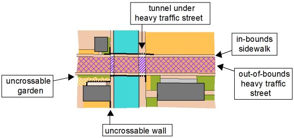 This snippet of an
imaginary map shows the mapping style and standards used in the downtown
Indianapolis map. There are two
multi-level symbols: Brown and white
indicating passage above and below pavement; Purple and white indicating
passage below the out-of-bounds street ONLY.
Olive green is used to indicate forbidden area (uncrossable)
gardens. On this map snippet, the only
way from the east part of the map to the west side of the canal is to use one
of the sidewalks to cross the canal on the bridge sidewalk (without crossing
the heavy traffic road). To go from
north to south, you must use the tunnels alongside the canal.
This snippet of an
imaginary map shows the mapping style and standards used in the downtown
Indianapolis map. There are two
multi-level symbols: Brown and white
indicating passage above and below pavement; Purple and white indicating
passage below the out-of-bounds street ONLY.
Olive green is used to indicate forbidden area (uncrossable)
gardens. On this map snippet, the only
way from the east part of the map to the west side of the canal is to use one
of the sidewalks to cross the canal on the bridge sidewalk (without crossing
the heavy traffic road). To go from
north to south, you must use the tunnels alongside the canal.
Course Setter (Robert
Minto) Notes:
On Blue and Red, there
is an off-the-clock street crossing and return. You have 30 seconds to
cross between punching the controls before and after the crossing (two pairs of
sequential punches).
Controls may be close
together but within the ISSprOM standard (min. 15
meters on different objects). Watch your codes.
Most importantly, the
vehicle traffic areas of some heavily used streets are out-of-bounds, marked
with purple hatching on the map. All sidewalks are in-bounds, even when
next to an out-of-bounds street. It may be tempting to cross but don’t; there may be course marshals.
Hot tip: As a general rule, if you want to cross busy
streets (darker brown with purple hatching), you need to go underneath along
the canal paths. If you want to cross
the canal, you generally need to come up to street-level sidewalks. The reality is a whole lot more complex
(Bwa-ha-ha!), but that is a good place to start.
Orange, Brown B, Green
(one green course for both Green A and B today only), Red and Blue will be on
Tabloid (11x17) landscape (horizontal) at 1:3000.
White and Yellow will be
on Legal (8.5 x 14) landscape at 1:3000
Brown A will be on Legal
(8.5 x 14) at 1:2500 and will have 2 map flips.
Part 1 and 3 are landscape on one side; part 2 is portrait on the other
side (be sure you locate north when you do the map flips).
updated
2025-04-03 at 0821