Race Details
Information
is still subject to change. Changes since
March 27 are shown in bold blue. There has
been an unusual amount of rain in the days leading up to the event. Conditions are wet and sloppy in all
areas. Shoes with spikes or very
aggressive tread are recommended for all areas.
It will likely be well below freezing on Friday and Saturday nights, and
the Saturday and Sunday highs may not reach 40 degrees F (4 C).
Maps
Saturday and
Sunday maps will be 1:10,000 scale. On Friday, the white, yellow, and brown
course maps will be printed at 1:7500.
Friday and Saturday maps have 5 meter contours; Sunday map has 2.5 m
contours.
Courses
All
standard USA courses and classes will be offered. Interscholastic courses will be offered for
the Air Force JROTC National Championships.
Practice Area
Practice
area maps will be available at registration.
Control Descriptions
Control
descriptions are printed on your map.
Loose description sheets may be picked up when you enter the call-up
area 2-3 minutes before your start.
Descriptions for white and yellow courses are in English only. Descriptions for orange course and above are
in IOF symbols only (ISCD2004).
Control Markers
Control
markers will be IOF standard orange and white flag. Control markers will have a blue stripe,
either diagonal or vertical.
Course Length (km) and Climb (m)
Table (subject to
change)
|
Course |
Friday –
Pyramid Hill – Middle Dist. |
Saturday
– Elk Creek – Classic |
Sunday –
Voice of America – Middle |
|
1 White |
2.2
km 90 m |
2.7
km 35 m |
1.7
km 20 m |
|
2 Yellow |
2.7
km 120 m |
4.0
km 50 m |
2.7 km 25 m |
|
3 Orange |
3.5
km 160 m |
5.8
km 100 m |
4.2
km 45 m |
|
4 Brown |
2.7
km 130 m |
4.6
km 85 m |
3.7
km 35 m |
|
5 Green |
3.6
km 140 m |
6.4
km 125 m |
4.2
km 40 m |
|
6 Red |
4.1
km 160 m |
7.6
km 150 m |
4.7 km 45 m |
|
7 Blue |
4.7
km 200 m |
10.2
km 200 m |
5.5
km 55 m |
Start Procedures
Clear and
check your SI card when you arrive in the start area.
You will be
called up 3 minutes before your scheduled start.
2 minutes before
your start, you will move forward and may pick up loose control descriptions.
1 minute
before your start, you will move forward to the map line. You may mark your name / number on the back
of the map. Do not look at your map. You may ask the starter to check that it is
the correct course.
When the
beeper sounds, you punch “start” and pick up your map.
There may
be a short streamered run to the start triangle shown
on your map (to be determined). You must
run to the triangle. There is a flag but
no punch at this point. At this point
you may begin navigating to your first control.
Drinking Water on
Courses
There will be at least one control
with drinking water on all courses of orange length and above. Please use the cups provided and dispose of
them in the bag or bin provided.
Time Limits
Time limit
will be 2 hours for all courses.
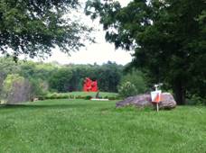
Friday, Apr. 6 – Pyramid Hill
Sculpture Park
photo credit: Mike Minium
Middle Distance
Scale 1:10,000, Contours 5 meters
Course Setter: Pat Meehan
Vetters:
Mike Minium, Dave Waller, Ben Hart
Consultant: Don Davis
Walk to Start: Event
Center, Check-in, and restrooms are 100-200 m flat road walk north of the
parking lot; Starts are 100-200 m flat road walk south of the parking lot.
Toilets: Indoor toilets will be available at the event
center / finish. Some vehicles may need
to park along the road from the parking lot to and past the event center.
Notes: Pyramid Hill is on the hills overlooking
the Great Miami River and city of Hamilton.
The park has large mowed meadows, with more than 50 monumental
sculptures, several buildings, and a network of roads and trails. There are several wooded areas, ranging from
very open in the developed parts of the park, to quite thick around the outer
edges. The terrain is hilly,
and steep in some areas. This is by far the
hilliest area of the weekend.
Course Setter Notes: to come
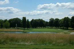 Saturday, Apr. 7 – Meadow Ridge Area of Elk Creek MetroPark
photo credit: Golf Advisor.com
Classic Distance
Scale: 1:10,000, Contours 5 meters.
Course Setter: Mike Minium
Vetter: Dave Waller, Ben Hart,
Matthew Robbins
Consultant: Don Davis
Walk to Start: less than 250 meters
from event center
Toilets: Portable toilets at parking
lot / event center.
Notes: Elk Creek MetroPark
consists of two distinct areas. Meadow
Ridge is a former 36 hole golf course and the area
still has many golf course features such as paved cart paths. The grasses are being allowed to grow, but runability on the former fairways is still open and very
fast. The Meadow Ridge area is not yet
open to the public – we will have exclusive use.
Around Meadow Ridge to the west and
south, steep and densely wooded hillsides descend some 60 meters to the flood
plain of Elk Creek. A couple horse
trails traverse the hillsides. The Elk
Creek flood plain consists largely of open fields and park land with a dozen or
so picnic shelters.
Course Setter’s Notes: The golf
course is very runnable and very fast. Most of the fairway and rough has been mowed
short. There are a few patches of tall
rough which may have a few thistles or brambles. Advanced courses will briefly venture into the
steep and thickly wooded hills surrounding the course, but 90% plus of all
courses should be very fast terrain.
Green circles and green dots have
been used for single trees and a few large shrubs. In a few cases I thought I’d have used a dot
instead of a circle for a particular tree, but in general I stayed with the mapper’s original representation. Some single trees may have a clump of bushes
around the base but are just mapped as a single tree, not as a copse.
Small patches of white “open forest”
are sometimes as few as 2 or 3 single trees with interlocking canopies, but open
grass underneath. Like the distinction
between green circles and dots, the mapper made a
decision; not everyone will agree on how they would have mapped every
particular tree or copse. In general, if
canopies of 2 or more trees connect, they are mapped as white, although in a
few cases, especially conifers, they are mapped as individual circles.
Larger patches of white forest are
very runnable, but may have some light deadfall or
undergrowth. Watch out for newly planted
1-2 meter tall trees in these areas; the park has been planting native
seedlings to replace hundreds of mature trees killed by emerald ash borer. Many dead ash trees have been cut down; the map has been
updated, so freshly cut stumps are not green dots or circles.
The very few boulders on the map are
small but quite obvious, most are only about 0.5 meter in height.
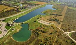 Sunday, April 8 – Voice of America MetroPark
photo credit: Bayer-Becker
Middle Distance
Scale 1:10,000, Contours 5 meters.
Course Setter:
Vetter:
Consultant: Don Davis
Walk to Start: 1 km flat paved path
Toilets: Indoor toilets at event
center, portable toilets by parking lot.
No toilets at the start
Notes: Voice of America is a
relatively flat area, that was mostly fields until a few years ago, that are
now overgrown with tall grasses and other vegetation. A dense network of trails
for cross country running and skiing or just walking and jogging wind through
the fields. The transmitter towers for the Voice of America radio
station were here, and large concrete “boulders” that supported the towers hide
in the fields. There are a few areas of
woods, some small wetlands and ponds, a manmade lake, and a manmade sledding
hill.
Course Setter’s Notes: Large sections of VOA are meadow / prairie
area. The mapper
has mapped almost all rough open area with closely spaced vertical green lines
(undergrowth, difficult to run). These
areas have varying quantities of thistle, and an occasional bramble. In general, I would have mapped many of them
with widely spaced lines (undergrowth, slow run), and there are also a few
places you can cross quite easily. The
best tip here is to look ahead to judge the density of thistle and possible
thorns. The park has recently used a brush cutter and
bush hog on many of the rough open areas.
These have been mapped as rough open with widely spaced vertical green
lines, or as rough open with no lines.
However, these freshly cut areas often have stubble that can trip the
unwary runner. Visibility is excellent,
but your speed may be slowed.
Boulders on this map are mostly
synthetic – concrete slabs that supported transmitter towers and guy
wires. Large “boulders” are quite
visible, often as much as 2 meters or more tall. But, the small “boulders’ can be as low as
barely protruding from the ground, and can be difficult to see in the prairie
vegetation. They have almost all been
mapped due to their historical significance, but they are generally not too
useful to an orienteer moving at speed.
Small boulders have only been used for controls when they are by
themselves, not clustered near many others.
In those few cases, the control flag is not hidden (even if the boulder
were high enough to hide it) and will likely be visible before you notice the
“boulder” itself.
updated
2018-04-03 1425